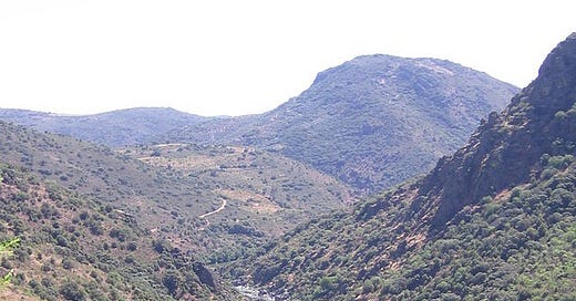
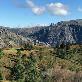
The deep valley rips for about 120 km from north to south, and brave and free waters run through its ancient stone gut. The deep, concave hollow of the bank harbours many old stories, which the tumultuous waters carry in their memory and distribute with each current and twist. Living memories of the depths of the earth, the roots that sprout from it, the legs that walk on it, the wings that fly over, and the fins that swim along the currents in a rich and complex matrix of life.
These waters are not calm and dont mirror the sky above. These are not waters that offer safety, no. These are living waters of a wild and restless river, sovereign and deep, noisy and agitated.
Potent currents pierce the rock, carving cliffs and feeding the valley. Fierce waters that welcome the seasonality of life. Ancient waters scream their power, waking us from the torpor of modernity, opening space through the white noise of technology, and cutting open the illusions of progress.
The wild waters know no borders, but people say they come from Spain, Zamora, and enter Portugal through the Montesinho mountain range. It is a peculiar place and route, for the depth of its valley, houses a microclimate that, over the last glaciations, became home and corridor of unique ecosystems in the world, a diverse community of life that includes numerous species now endangered protected by international laws and conventions. This valley has become a refuge for a delicate singular diversity of plants, mammals, reptiles, birds, amphibians, fish, and insects in more than 20 distinct habitats, wild and living relics that hold irreplaceable genetic heritage unfolding life in deep time. An untamed sanctuary with the presence of humans since ancient times, as witnessed by the rock figures found in various areas along the valley dating from the Upper Palaeolithic period (30,000–8,000 B.C.).
The gorge of this wild river valley, the last in the Iberian Peninsula, holds unique traces of the evolutionary memory of life in this region, playing an essential role in sustaining the rich biodiversity and body-psyche’s-soul of all of us.
After millions of years of vibrant life, and after the first move in 1996, on June 30, 2008, the silencing of these waters was decided, by now imprisoned by a volume of 1,102,240 cubic meters of concrete at a total cost of 569 million euros, silencing the ancestral echo of this untouched place. In 2016, when the “mother of all dams” was inaugurated, the brave currents of these ancient waters were tamed by 14,710 tons of reinforcing steel. About 13 kilometers from the mouth of the river, the dam strangles its soul, breaking the knots of its intertwined and singular life, suffocating the valuable life that existed here. 2.937,8 cubic meters of entrails of earth and stones were excavated from its banks, tearing the landscape into open wounds with no time for regeneration.
Now the sovereign and brave river has been silenced, drowned in itself, as the dam flooded an area of about 3660 hectares of wild territory.
The place has changed, losing its former complexity, almost extinguishing all the invaluable ecosystem, mutilating the strength and memory of the wild water. The river’s living waters and territory are now spread over three complacent lakes, and in half its course, the water covers up to 234 meters deep of the valley. The steep banks have almost disappeared, submerged in tamed water full of sediments. The abrupt, wild gorge has now been domesticated for the narrative of technological progress and voracious energy demand.
It takes 70 kilometers from the dam to the mouth of one of its tributaries, with three large lakes linked together by canyons and cliffs. The Lake of Cilhades, the largest of the three, is named after the submerged ancient Iron Age village. This large lake is connected through the gorge of Fraga do Fojo to the Lake of Sanctuaries, which owes its name to an 18th-century church that existed here, a building that was transported from the flooded area piece by piece and rebuilt on top of the Parada hill (the ecosystem sanctuary could not be moved, just flooded). Finally, the Sanctuaries Lake is connected to the third lake, the Medal Lake, through the Aguilhão strait. With the submersion of the territory, besides the ecosystemic loss, about 200 points of cultural heritage, ethnographic, historical, and archaeological interest were destroyed.
A public manifesto, signed by more than 260 researchers, tried to avoid this foretold death, alerting to the loss of something of incalculable value, sponsoring in the process as representatives of the wild waters all the way to the European legal court.
Several associations, NGOs, scientists, and local people have attempted to prevent the destruction and save the remains of the Mediterranean forest of holm-oaks, cork oaks, and the valuable nuclei of wild vines and olive trees. They set out to defend the nesting sites of Bonelli’s eagle, the golden eagle, the Egyptian vulture, the peregrine falcon, the Eagle-owl, and the Black stork, which have also lost their native hunting grounds. They wanted to safeguard the ecological corridor that guaranteed communication between several vital species groups, such as the Iberian wolf, the water mole, the otter, the wildcat, and the roe deer. Before the dam, the animals could pass from one bank to the other, keeping genetic diversity between groups. People joined forces to preserve, around the dam area, the main spawning grounds for a critical fish community in the large area of the Douro basin. But the fish can no longer move through the living waters of the river, prevented from migrating by the concrete walls. The pike has also reached the mouth of the old wild river and now preys on the local fish, the bogas, and bardos. In unison, these voices have relentlessly warned of the loss of fertile areas, such as the valley of Felgar, its cultivation of extremely high-quality almonds and olive oil, and the affected human populations in the area.
These waters are now placid and mirrored … yes. Waters that carry the illusion of security and the corrupted promise of development. But we have lost the river and its living, wild and raging deep waters no longer own themselves.
The river’s name is Sabor.
The danger of promises
It is not new that dams favour the release of toxic substances into the water by promoting high levels of nutrients such as phosphates and nitrates, giving way to the accumulation of decaying organic matter and the depletion of dissolved oxygen. These toxic processes contribute to the retention of sediments, deteriorating the water quality and promoting profound changes along its course, degrading and destroying the habitats that depend on it and weakening the entire ecosystem.
The ecological system of this quality and importance was destroyed with the beginning of the dam construction in 2008, based on some promises, which ignored what was already known about the dangers of dams and their irrecoverable environmental impacts. The perversion is that the Sabor dam was built based on the need to adjust energy production to meet the targets set by the Kyoto Agreements that demanded a drastic reduction in CO2 emissions (the deadline was never met).
We have thus condemned an ancestral, valuable, and unique ecosystem to an illusion of “green” energy production. Once again, ignoring that the climate crisis is systemically complex and that one of its main vectors is the huge loss of biodiversity and habitats, the so-called ecocide.
The government promises were:
Energy promise — insufficient to secure EU financial support. The contribution of the Sabor Dam, represents only 0.17% of the total CO2 emissions and 0.7% of the necessary effort (0.15 Mton of the 21 Mton CO2 that, according to the National Plan of Climate Change, would need to be reduced) to achieve the goals of the Kyoto Protocol, and 0.6% of the energy consumed, assuming itself as insignificant at a national level, given its high financial and environmental costs. In addition, dams have a very short lifespan, usually between 50 and 70 years, making their subsequent maintenance costly and their dismantling extremely complicated and with very high associated costs.
“Reduction” of CO2 emissions — according to the dam’s official website, 1,037 kt (direct and indirect) emissions are avoided yearly. But the potential of the vast forest area in the area was never accounted for, nor was the abundance of CO2 and methane released by the reservoir (this occurs in all reservoirs due to the degradation of organic matter in anaerobiosis), nor the use of thousands of tons of cement, whose production implies the emission of a large amount of CO2 (about 1.25 tons of CO2 for each ton of cement produced).
Strategic water reserve — for irrigation and tourism purposes, in a severe demonstration of ignorance about the biophysical and socio-demographic limitations of the region, as mentioned by some authors. Irrigation uses the water from this reservoir, located in a profound and isolated valley that does not allow the construction of a water transportation system, so the stored water is limited to energy production. The use of the reservoir for tourism and recreation purposes is strongly conditioned by the large gradients of the water storage; in addition to the land without vegetation and covered in mud and the marked degradation of the water quality due to the high storage periods in an area where very high temperatures are reached (which creates an enormous limitation in its use for bathing purposes, as well as the restrictions inherent to its SPA status preventing the practice of motorized water sports).
Regional development and “nature conservation” — Trás-os-Montes is one of the regions in Portugal and Europe with the highest density of dams. Yet, it remains one of the least “developed.” The construction of the Baixo Sabor dam means the irreversible destruction of priority and local cultures, such as in the valley of Felgar — one of the most fertile areas in the whole area — where around 60,000 litres of high-quality olive oil (0.2º acidity) are produced annually, promoting the abandonment and progressive deterioration of rural territories.
Six years after the dam’s inauguration, some wine producers won. The winners were those who built it, in a “great” feat of engineering and technique. We all lost in biodiversity, the intrinsic value of the territory, and the preservation of valuable life. A Life that slips through our fingers with every short-term “green” idea. The local councils came together to create a sustainable tourism network in the “great lakes,” still without legal permission to enjoy the lakes…
I have often imagined visiting the wild river. I never managed to do so. Although I have not touched it, I have heard it. I still mourn that loss, the last wild river in the Iberian Peninsula.
We remain unaware of how much of our soul, body, and psyche are mutilated and superficialized in these violent technological conquests. Nevertheless, I know that for now, the free water still comes out of the spring 1600 meters high, daring to travel the same furrowed path in all its strength and wisdom.
Torn identity
We are the places we inhabit. They bring us stories, presence, and belonging. We walk over them, bathe in their waters, and nourish ourselves with their food. From them, we create and share memories that sustain culture and community. That gives ground to who we are.
Echoes of the wilds
A few years ago, I woke up feeling lost and grieving. I dreamt of being wild, utterly in kinship. When awake, I mourned the ancient and profound loss of keen senses and radical awareness, of living ritually as an integral part of the cosmos. Before humans learned to fear ourselves, we lived in
Whoever colonizes was colonized.
With all its destruction, cruelty, fury, and coercion, the violence of colonization was also used in us. Even more so in the past, it is very present as cultural trauma. Although much more previously, we were also colonized through roman imperialism, genocide, inquisition, wars, and conquests. For centuries, we lived as …
A fish, a glass of milk, and irrelevant territories
Fish When we think of fish, we get entangled with the ocean. Its depths, currents, underwater forests, tides, diverse ecosystems, shallow waters, abyssal darkness, tropical waters, or icy storms. Or we might connect to a lake or a river, with its freshwater flows, streams, and dynamic rhythms of the ancient wild waters.
Comfort as violence
I am a forty-something-year-old white woman from Southern Europe. That’s in the global north, and I live a comfortable and peaceful life. Of course, there are challenges, responsibilities, and preoccupations. As a woman, I must endure the engrained misogynist experience in social life. Being from Southern Europe, I also…
Resources and References:
https://www.cimpor.com/-/aproveitamento-hidroeletrico-do-baixo-sabor
http://ambio.blogspot.com/2004/06/especial-sabor.html
https://quilometrosquecontam.com/rio-sabor/
http://ciara-baixosabor.pt/
The Sabor Livre Platform was formed by Quercus, LPN, Fapas, GEOTA, Olho Vivo and SPEA, who came together to safeguard the Sabor River without dams. This movement also has the support of: Environmental Defense and ADEGA, Adenex, ADP Mértola, Água Triangular, ALDEIA, Almargem, Amigos da Montanha, Amigos do Mar, ANATA, A Rocha, Associação Vento Norte, Campo Aberto, CEAI, CEEA, Clube Celtas do Minho, Coagret, Corema, Crepúsculos, Ecologistas en Acción, Euronatura, Federation of Environmental and Ecological Organizations of Cyprus, FAPAS (España), FEG, GAIA, Grupo Flamingo, IRN, Melgaço Radical, Molima, NEPA-AAUTAD, Nuceartes, Oikos, Projecto Palhota Viva. Later the Instituto de Conservação da Natureza (ICN) and the IPA (Portuguese Institute of Archaeology) also joined.


